Baghdad: Mapping the violence

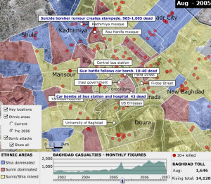
Monthly figures for civilian casualties are from Iraq Body Count which uses at least two media reports as the source for each death. We have used a mean number of IBC's minimum and maximum figures for each month.
More details on Iraq Body Count's methodology are available on their website.
Attacks resulting in more than 10 dead are located as accurately as possible from reports since 2003. Where an exact location is not possible, in areas such as Sadr City, the marker has been placed within the district.
If you click on the link, you will be taken away from the map to the BBC News website story. Casualty figures in the story are as reported at the time and may differ from the link.
The ethnic divisions are from the International Medical Corps.
The breakdowns relate to people's recollection of the ethnic mix under Saddam Hussein until February 2006 and the present day situation.
The satellite image of Baghdad is from Landsat imagery courtesy of Nasa Goddard Space Flight Center and USGS Center for Earth Resources Observations and Science.
The BBC is not responsible for the content of external internet sites


