


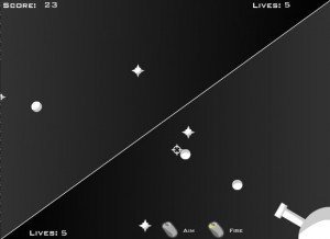


GOES-R Flight Controller
How is an eagle like an airplane?
Well, they both fly. But as high and fast as the plane may fly, the eagle has something the airplane doesn't. The eagle has a wide view of his whole world and acute eyesight. He can see everything he needs to see, both in the air and on the ground, for as far as he plans to fly.
Not so the airplane. Airplanes have radar that can detect turbulence and other planes a few miles out. But when a plane is going 500 miles per hour, it covers a long distance in just a few seconds—very little time to avoid hazards. And there are some hazards that planes don't see—like fine, powdery volcanic ash floating in the air. As you know from "The sky is broken," this stuff is very bad for airplanes.
Now, how is an eagle like the satellites in the GOES-R series? Like the eagle, satellites in the GOES-R series have a very wide view of the world, and excellent eyesight. First, the satellite is in geostationary orbit, so high above the equator that the satellite's imager—its "eyes"—can see Earth as a whole disk. Now that's a birds' eye view.
What's more, the new R series of Geostationary Operational Environmental Satellites (GOES) have very advanced sensor technology. Using its new imager, plus new techniques for processing its data, it will be able to warn of fine volcanic ash floating in the air. This information will help aviation agencies to steer pilots around them.
Its imager data is also used to detect high-altitude updrafts shooting over the tops of storm clouds that could create hazardous turbulence for aircraft.
Photo from space showing night side of Earth with numerous bright spots where lightning storms are occurring.
The GOES-R series also detects and maps lightning. Data from its Lightning Mapper will show where the lightning storms are happening across the entire U.S. at once. Lightning is a very serious aviation hazard!
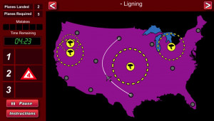
Play GOES-R Flight Controller, and help plan hazard-avoiding flight paths for passenger planes flying between cities. You will have the help of three types of "real-time" and computer-processed data from a GOES-R series weather satellite. See if you can make it all the way to "Expert Flight Controller."